
IODP Expedition 306:
North Atlantic Climate 2
Week 2 Report
PDF file is available for download.
March 20, 2005
Operations
HOLE U1312B: Coring continued in Hole U1312B through Core 17H to a depth of 155.9 mbsf. The core line failed at the rope socket while attempting to recover Core 18H necessitating a wire line fishing trip for the core barrel and sinker bar assembly. Coring continued through Core 25H to a depth of 231.9 mbsf as weather conditions progressively deteriorated. This led to another damaged core line at the rope socket and twisted piston rods. As the sea state continued to worsen the core line was re-headed and the APC rods were repaired. Before repairs to the coring system were completed weather conditions had deteriorated to a point that precluded any additional coring. A wind shift and increased velocity forced a heading change to maintain position over the hole. This caused excessive roll as the ship was exposed to multiple large swells coming from different directions. With concern expressed by the electrical supervisor about the ability to keep the ship on location the drill string was pulled out of the hole (POOH) clearing the seafloor at 0245 hours. The ship was allowed to drift off location to minimize vessel motion during the remainder of the pipe trip. By 1700 hr 14 March the ship was secured and began the slow DP move into the prevailing seas back over the drill site. At 0430 hr 15 March positioning beacon SN 2199, 15 kHz, 211 dB was recovered. This officially ended operations for Hole U1312B and Site IRD-04A.
Tensor core orientation was used for all cores beginning with Core 4H. The "drill-over" technique was required only for the recovery of Core 25H and all core barrels fully stroked. Non-magnetic core barrels were used exclusively for all 25 cores. The cored interval for this hole was 231.9 m while 236.84 m were recovered for an average recovery of 102.1%.
Rather than wait-on-weather (WOW) for an extended and indefinite period of time, Site 1312 was abandoned after completing only 2 of the 3 scheduled holes. While the depth of penetration did not reach the projected 300 mbsf it was confirmed that the holes did penetrate through the upper Miocene, which was the scientific goal for this site.
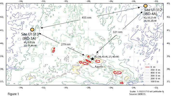
TRANSIT TO SITE U1313 (Prospectus Site IRD-03A): The transit to Site U1313 was arduous as the vessel was continually pummeled by high seas, swells, and high winds. Unable to steam under full power the transit was made at reduced "turns" on the main shafts to prevent the main screws from coming out of the water and to keep the nose of the ship from burying into the large swells. Advanced weather forecasts received during the transit indicated that a series of deep low pressure cells was tracking across Site 1313 (IRD-3A). With storm force winds as high as 65 knots forecast, it was apparent that we would not be able to conduct coring operations on site. The vessel diverted to a sheltered area in the lee of the chain of Azorean islands consisting of Sao Jorge, Pico, and Terceira (Fig. 1). The 361 Nmi transit to this location was made at an average speed of 4.9 knots and at 0800 hr 18 March the thrusters were lowered and the vessel was switched into DP control.
STANDING BY (WOW): As of Sunday, 20 March, the drill ship remained in DP mode positioning in the lee of the Azorean Islands of Sao Jorge, Pico, and Terceira. Weather forecasts from NOAA, United Kingdom, Canada, and Europe are being monitored several times daily. Optional operations plans along with the latest weather forecasts are being considered in daily meetings. Sunday's forecasts call for storm force winds at Site IRD-3A starting to diminish by Friday. Hope remains that the ship might be able to get underway for Site 1313 (IRD-3A) around the middle of next week and be in position to begin on-site operations sometime Friday, 25 March. Site IRD-3A is ~290 Nmi away or 1.3 to 2.0 days away at speeds of 6.0 to 9.0 knots.
Preliminary Scientific Results, Site U1312 (IRD-4A)
The sedimentary sequence recovered from Site U1312 comprise Holocene to upper Miocene nannofossil oozes and foraminiferal nannofossil oozes with minor amounts of (silty) clay. Mainly based on sediment color, carbonate content, and reflectance values, two lithological units were distinguished. Unit I (0 to about 79 mbsf; Holocene to late Pliocene) is characterized by alternating color bands (pale brown, light gray, grayish brown, gray, light gray and white), variable carbonate contents between 59 and 96%, and high-amplitude variations in reflectance values. Unit II (about 79 mbsf to the bottom of the holes; late Pliocene to late Miocene) is predominantly white nannofossil ooze with carbonate contents > 95%. Thin greenish and light gray laminae frequently occur in the upper part of Unit II.
The biostratigraphic framework of Site U1312 was built upon a series of calcareous nannofossil, foraminifer, diatom and radiolarian events. Average sedimentation rates were low during the late Miocene (1-2 cm/ky), increasing in the Early Pliocene (between 3 to 8 cm/ky) to decrease again in the latest Pliocene and Pleistocene (~1.5 cm/ky). Preservation of calcareous microfossils was good in both holes with the exception of some intervals in the latest Miocene where most of the planktonic foraminifers were fragmented or showed strong signs of dissolution. In contrast, siliceous microfossils were poorly preserved in the Pleistocene and latest Pliocene, and completely barren in lower Pliocene and upper Miocene sediments. With the present sampling resolution, the presence of a hiatus in the sedimentary record cannot be totally discarded, especially in the latest Pliocene and latest Miocene.
The Brunhes/Matuyama boundary occurs at 18.4 mbsf in Hole U1312A, and at 16.95 mbsf in Hole U1312B. The Jaramillo Normal Polarity Zone corresponds to the depth interval 20.9-24.8 mbsf in Hole U1312B. The reversals present in the underlying sediments were more difficult to characterize. In conformity with the biostratigraphy, the Gauss/Matuyama boundary was placed at 51.6 mbsf in Hole U1312B. Between about 80 and 200 mbsf, the magnetostratigraphy is less clear. It improves again below ~200 mbsf, where a long interval of normal polarity is tentatively identified as Chron 5, which would place the bottom of Hole U1312A at ~11 Ma.
Stratigraphic correlation was difficult at Site U1312 due to a very uniform sediment composition and coring deformation in Hole U1312A. Magnetic intensity of the NRM and color reflectance parameter L* (lightness) proved most useful for correlating between the two holes. A complete composite section was constructed for the interval 68 to 159 mcd. Marine oxygen isotope stages and the transition from 41 to 100 ky orbital cycles are nicely mirrored in the sediment lightness record obtained at Site U1312.
Site U1312 science meeting was held on Thursday and scientists gave presentations and had lively discussions of their scientific results. By late Saturday night all Site U1312 reports had been submitted to the Co-Chiefs office for review. Various meetings, presentations, workshops and ship tours have been scheduled for while the JOIDES Resolution is on standby (WOW) in the Azorean islands.
Technical Support and HSE Activities
Underway watches and bottom depth profiling began soon after abandoning Site U1312 en route to a sheltered location for the ship in the Azorean archipelago. The magnetometer sensor was not deployed during transit, as the ship's speed was generally under 5 kts. The weather panels that protect the core-receiving platform were repositioned for better support.
The proposal to freeze and cut core sections during Expedition 307 initiated a feasibility test. A short mud line display core was frozen and cut with the splitting saw, without water. The frozen core liner fractured when handled and the caps popped off but an added liner patch stabilized the section enough to split it successfully.
LABORATORY STATUS: Lab activities during and after the first site presented a number of problems with instrumentation and software. Cores passed over prior to abandoning U1312 were brought back to the core lab for AMST measurements. The instrument has had problems and is still failing irregularly. The cause of the problem has not been identified, but work-a-rounds have allowed all the sections to be scanned. Testing continued on the Mettler balance system, producing data sets in heavy seas and now in DP mode with moderate movement. MST communications problems between the array of sensors and the controlling computer are believed to be corrected. WOW has presented an opportunity to start the upgrade of the XRD, with newer cards and software.
HSE: Heavy weather resulted in the lifeboat drill, scheduled for Tuesday, being conducted inside the ship. The use of survival suits was demonstrated and all personnel were urged to take their suits to their room to inspect them for damage and to assure individuals that they were sized correctly. A selection of safety videos for the TAMU specialists to review was posted. Hydroblasting was conducted on the bow and continues on the main deck.