
IODP Expedition 318
Wilkes Land Glacial History
Daily Science Report for 28 February 2010
LOCATION: Site U1361 (WLRIS-05A; 66°24.57'S, 143°53.20'E, water depth 3470 mbrf)
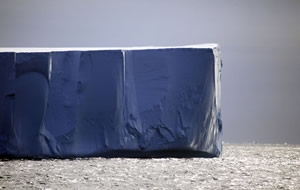 SCIENCE UPDATE: XCB Cores U1361A-40X to 41X penetrated from 368.9 to 388.0 mbsf and recovered 17.7 m (93%). Sediments recovered are late Miocene clays and silty clays with varying amount of diatoms; a few dispersed clasts; a few thin carbonate-rich intervals including nannofossil oozes. After Core 41X was recovered, we had to suspend coring to deploy a free fall funnel because an iceberg was moving directly at the site. We pulled the bit out of the hole at 0945 hr and moved out of the iceberg's path as it passed over the hole. We moved back over the hole, reentered it at 2137 hr, and began preparations for downhole logging. We plan on departing no later than 2400 hr on 2 March.
Daily Science Report for 27 February 2010
LOCATION: Site U1361 (WLRIS-05A; 66°24.57'S, 143°53.20'E, water depth 3470 mbrf)
SCIENCE UPDATE: XCB Cores U1361A-19X to 39X penetrated from 167.8 to 368.9 mbsf and recovered 152.5 m (76%). Sediments recovered are middle to late Miocene clays and silty clays with varying amount of diatoms; a few dispersed clasts.
Daily Science Report for 26 February 2010
LOCATION: Site U1361 (WLRIS-05A; 66°24.57'S, 143°53.20'E, water depth 3470 mbrf)
SCIENCE UPDATE: Today we began coring in Hole U1361A. APC Cores U1361A-1H to 16H and XCB Cores 17X to 18X penetrated to 167.8 mbsf and recovered 169 m (101%). Sediments recovered are Late Miocene to Pliocene clays and silty clays with varying amount of diatoms; a few dispersed clasts.
Daily Science Report for 25 February 2010
LOCATION: In transit; Arrive at Site U1361 (WLRIS-05A; 66°24.57'S, 143°53.20'E, water depth 3470 mbrf)
SCIENCE UPDATE: Today we made a final attempt to reach sites on the Antarctic continental shelf. Based on remote sensing data and our experiences during this expedition, Site WLSHE-12A was the only one we thought there was a chance of reaching. We had to reduce speed due to heavy fog and mist (although flat seas) as we entered the continental shelf. As we approached Site WLSHE-12A, we started encountering pancake ice and small bergy bits; concentration of ice increased the closer we came to the site. The fog gradually lifted, but when we were ~5 nmi from Site WLSHE-12A the ice became too thick to continue. At 0840 hr we turned around and began our transit to an alternate site on the rise (WLRIS-05A). We arrived at Site U1361 (WLRIS-05A) at 1945 hr.
Daily Science Report for 24 February 2010
LOCATION: Hole U1359D (64°54.26'S, 143°57.56'E; 3012 mbsl)
SCIENCE UPDATE: After waiting for daylight, we deployed the Vertical Seismic Imager (VSI) to conduct a check shot. This was our third logging tool string run in Hole U1359D. The VSI made it down to 5 m from the bottom of the hole, but the caliper arm would not open. However, by setting the tool on the bottom of the hole, we were able to get enough coupling with the formation to receive a good signal from the seismic source at surface. After successful logging in good hole conditions, we decided to end operations at Site U1359 so that we could make one last attempt at the shelf sites. We retrieved the drill string and departed for Site WLSHE-12A at 2245 hrs.
Daily Science Report for 23 February 2010
LOCATION: Hole U1359D (64°54.26'S, 143°57.56'E; 3012 mbsl)
SCIENCE UPDATE: Two very successful downhole logging runs were completed in good hole conditions. The Triple-Combo and FMS-Sonic tool strings were able to log the entire hole from 602 mbsf up to the end of the pipe at 97 mbsf. The FMS-Sonic tool string was back on deck at 2000 hr. We will have to wait until daylight to conduct the check-shot.
Daily Science Report for 22 February 2010
LOCATION: Hole U1359D (64°54.26'S, 143°57.56'E; 3012 mbsl)
SCIENCE UPDATE: Final cores from Hole U1359D (Cores U1359D-40R to 48R) penetrated from 516.2 to 592.6 mbsf and recovered 39.6 m (46%). Cores are middle Miocene diatom-bearing bioturbated silty claystones interbedded with finely-laminated silty claystones. Just before noon, we began preparing the hole for downhole logging and the first logging tool string was being assembled just before midnight.
Daily Science Report for 21 February 2010
LOCATION: Hole U1359D (64°54.26'S, 143°57.56'E; 3012 mbsl)
SCIENCE UPDATE: RCB Cores U1359D-17R to 39R penetrated from 295.9 to 516.2 mbsf and recovered 105.7 m (48%). Cores U1359D-8R to 24R have been split and contain late Miocene diatom-bearing silty claystone and claystones; all contain dispersed clasts.
Daily Science Report for 20 February 2010
LOCATION: Site U1359 (64°54.26'S, 143°57.56'E; 3012 mbsl)
SCIENCE UPDATE: After lowering the drill string down the seafloor, we drilled without coring to 152.2 mbsf. We started RCB coring at that depth to overlap with previous APC/XCB coring that extended to 252 mbsf. RCB Cores U1359D-2R to 16R penetrated from 152.2 to 295.0 mbsf and recovered 124.9 m (87%). Cores split so far (U1359D-2R to 7R) are Pliocene to Late Miocene(?) diatom-bearing silty clay with dispersed clasts.
Daily Science Report for 19 February 2010
LOCATION: Arrived Site U1359 (64°54.26'S, 143°57.56'E; 3012 mbsl)
SCIENCE UPDATE: We continued around to the northern edge of the ice tongue to re-occupy Site U1358 (WLSHE-08A). The path to Site U1358 was blocked by ice so we tried to get to alternate shelf site, WLSHE-12A, to the north of Site U1358. We could only get within ~3 nmi of that site because of heavy ice. Present ice conditions prevent occupation of our shelf sites, so we are moving back to Site U1359 (WLRIS-04A) on the rise to complete the RCB portion of the coring program.
Daily Science Report for 18 February 2010
LOCATION: In transit to Site U1358 (WLSHE-08A)
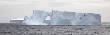
 SCIENCE UPDATE: After spending the previous day trying to find a path through the ice to reach Site U1360 (WLSHE-09B) from the north, we sailed around the western edge of the growing ice tongue. We had another spectacular day with views of icebergs of all shapes and sizes, penguins, at least one whale, the French Antarctic base, and the vast Antarctic ice sheet rising high inland. However as we approached Site U1360 from the south and west, we were only able to get within 8 nmi of the site when a heavy concentration of pack ice and icebergs blocked access to the site. We reluctantly reversed course and began heading west in order to move back around to the northern edge of the ice tongue. We plan on attempting to re-occupy Site U1358 (WLSHE-08A). If ice coverage prevents this, we are evaluating existing alternate sites that are further out on the shelf that have less concentrations of ice.
Daily Science Report for 17 February 2010
LOCATION: Attempting transit to Site U1360 ((WLRIS-09B)
SCIENCE UPDATE: We spent the day attempting to find a clear path to Site U1360 (WLSHE-09B). Dense pack ice and icebergs blocked our direct path to the site. Over a distance of ~80 nmi, we made four attempts to penetrate the northern edge of the ice barrier. Unfortunately, each time we had to reverse course when the end of an apparent opening was reached. We decided not to make any more attempts during darkness and in snow flurries causing poor visibility. We moved away from heavy ice (~104 nmi from Site U1360) and are waiting until we can try again with the first light tomorrow. Winds up to 22 knots, seas/swells up to 8 feet, air temperature of -2°C; snow flurries in evening.
Daily Science Report for 16 February 2010
LOCATION: Waiting on weather; In transit to Site U1360 (WLRIS-09B)
SCIENCE UPDATE: After severe weather conditions abated, we began our transit back to Site U1360 at 1000 hr. Transit speed and course being adjusted to ensure we don't overtake the storm south of us and to time arrival at ice pack edge at first light tomorrow. Held science meeting to discuss initial results from Site U1359. Winds up to 30 knots, seas/swells up to 15 feet, air temperature of -1°C.
Daily Science Report for 15 February 2010
LOCATION: Waiting on weather (64°57.6'S, 140°54.7'E)
SCIENCE UPDATE: Weather conditions were too severe for operations so we waited out the storm in deep water ~50 nmi north of the ice pack and ~90 nmi north of Site U1360 (WLSEH-09B). Wind gusts up to 62 knots (71 miles/hour – just below hurricane force), seas up to 30 feet, snow flurries (mostly sideways!) reduced visibility to 0.5 nmi; rolls up to 8° and pitch up to 5°. Ship offset due at 1800 hr due to iceberg on radar. Planning to return to Site U1360 following storm and ice-conditions permitting.
Daily Science Report for 14 February 2010
LOCATION: Site U1360 (WLRIS-09B; 64°22.0384'S, 142°44.7083'E; Water Depth 506 m)
Transit to Standby Position (65°00'S, 140°55.6'E)
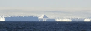
SCIENCE UPDATE: After abandoning Hole U1360A due to an approaching iceberg, we retrieved the drill string. Icebergs remained over the site so we couldn't retrieve the seafloor beacon; however, we plan on returning to the site after the passage of a severe weather system. We departed at 0615 hr and moved ~90 nmi north of Site U1360 (~50 nmi north of the ice pack) where we will wait until the storm abates early Tuesday. On our way north out of the ice, we had incredible views of icebergs, sea ice, and penguins on icebergs. Winds up to 28 knots, seas up to 6 feet, and air temperature of 1°C.
Daily Science Report for 13 February 2010
LOCATION: Site U1360 (WLRIS-09B; 64°22.0384'S, 142°44.7083'E; Water Depth 506 m)
SCIENCE UPDATE: Started RCB coring in Hole U1360A (WLSHE-09B). Cores U1360A-1R to 7R penetrated to 70.8 mbsf and recovered total of 7.04 m; recovery varied from 0 to 30% (average 10%). Clast-rich sandy diamict; claystone and sandy mudstone with dispersed clasts (clasts include mudstone, basalt, gneiss). Section extends into early Oligocene but short of our primary objective. We started to prepare a free-fall funnel so that we could attempt to return to the same hole after the next severe storm. Unfortunately, the hole had to be abandoned due to an approaching iceberg before it could be deployed. We plan to return to this site, but are moving to deeper water to avoid riding out next intense low pressure system among the ice and in shallow water. This system is predicted to arrive tomorrow night with gust up to 60 knots and poor visibility due to snow flurries.
Daily Science Report for 12 February 2010
LOCATION: In Transit to and arrived at Site U1360 (WLRIS-09B; 64°22.0384'S, 142°44.7083'E; Water Depth 506 m)
SCIENCE UPDATE: Departed Site U1359 (WLRIS-04A) at 0015 hr. Our transit to Site U1360 (WLSHE-09B) began in gale force winds and rough seas but improved during the day. As we moved south, we began encountering numerous icebergs. About ~15 nmi from the site, pack ice and grounded icebergs blocked a direct path to the site and we had to deviate ~30 nmi to the west to pass around the ice. Incredible views of icebergs along the way! Temperatures of -5°C combined with 35 knot winds result in a wind chill of ~-20°C; ice is forming on the deck and outside bulkheads. We arrived at Site U1360 at 1800 hr and began monitoring ice in drilling area. We then had to wait until nearly midnight to allow icebergs to pass over the drill site.
Daily Science Report for 11 February 2010
LOCATION: Site U1359 (WLRIS-04A; 64°54.2374'S, 143°57.6805'E; Water Depth 3021 m)
SCIENCE UPDATE: APC Cores U1359C-1H to 18H penetrated to 168.7 mbsf and recovered 150.7 m (89%). Cores recovered silty-clays with dispersed clasts and extend into the late Miocene. We stopped coring at 1445 hr so we can depart for high-priority shelf site (WLSHE-09B) targeting the Eocene-Oligocene transition this evening. Our departure is timed to take advantage of a forecast "reasonable" weather period on shelf. Winds up to 32 knots, air temperature of 0° (wind chill down to about -9°C), swells up to 10 feet.
Daily Science Report for 10 February 2010
LOCATION: Site U1359 (WLRIS-04A; 64°54.2374'S, 143°57.6805'E; Water Depth 3021 m)
 SCIENCE UPDATE: APC Cores U1359B-8H to 23H penetrated from 64.7 to 209 mbsf and recovered 131.5 m (91%). Extended penetration with Cores U1359B-24X to 28X from 209 to 252 mbsf and recovered 15.3 m (35%). Cores recovered are silty-clays with dispersed clasts and extend into the late Miocene. We stopped XCB coring (in part due to large swells causing heave up to 18 feet; winds up to 28 knots) and offset ship 25 m WSW to prepare for APC coring in Hole U1359C. We plan to depart for high-priority shelf site (WLSHE-09B) targeting the Eocene-Oligocene transition late Thursday. Our departure is timed to take advantage of a forecast of "reasonable" weather on shelf.
Daily Science Report for 9 February 2010
LOCATION: Site U1359 (WLRIS-04A; 64°54.2374'S, 143°57.6805'E; Water Depth 3021 m)
SCIENCE UPDATE: APC Cores U1359A-8H to -17H and -18X to -22X penetrated from 57.5 to 193.6 mbsf and recovered 109.7 m (81%). Sediments are Pliocene-Pleistocene silt-clay with occasional clasts. To get the complete section, we decided to offset 25 m WSW of the first hole and APC core in Hole U1359B. Cores U1359B-1H to 7H penetrated from 0 to 64.7 mbsf and recovered 52.5 m (81%).
Daily Science Report for 8 February 2010
LOCATION: Site U1359 (WLRIS-04A; 64°54.2374'S, 143°57.6805'E; Water Depth 3021 m)
SCIENCE UPDATE: Shortly after midnight we arrived at Site U1359 (WLRIS-04A) and lowered the thrusters. After waiting for the weather to abate, we started lowering the drill string at 0700 hr. APC Cores U1359A-1H to -7H penetrated to 48.1 mbsf and recovered 44.43 m (77%), with good recovery (>94%) in all but one core. Sediment is Pleistocene silty-clay and clayey-silt; contains dispersed clasts.
Daily Science Report for 7 February 2010
LOCATION: Site U1358 (WLRSHE-08A; 66° 05.4239’S, 143° 18.7707’E; Water depth 510.3 mbrf), and
In transit to Site U1359 (WLRIS-04A; 64°54.2375'S, 143°57.6805'E; Water Depth 3086 m)
SCIENCE UPDATE: We began RCB Coring in Hole U1358A on the Antarctic continental shelf. Core U1358A-1R penetrated from 0 to 2 mbsf and recovered 1.10 m of clast-rich sandy diamict. The hole had to be abandoned due to an approaching iceberg. We then started RCB coring in Hole U1358B. Cores U1358B-1R to -4R penetrated from 0 to 35.6 mbsf and recovered 8.0 m (22%) of clast-rich muddy diamict and sandy diamictite (< mid-Pliocene). Clasts include basalt, granite, gneiss, quartzite, and gabbro. We were unable to continue coring after lowermost part of bottom hole assembly broke off in hole. We retrieved the drill string and headed out to deeper water to avoid riding out a storm among the ice and in shallow water. We arrived at Site U1359 (WLRIS-04A) at midnight.
Daily Science Report for 6 February 2010
LOCATION: Site U1357 (ADEL-01B; 66° 24.80'S, 140° 25.50'E; Water Depth 1026 mbrf)
Site U1358 (WLRSHE-08A; 66° 05.4239’S, 143° 18.7707’E; Water depth 510.3 mbrf)
SCIENCE UPDATE: We began the day by waiting on weather and ice; sea conditions improved during the morning as the storm abated. The weather forecast indicates tomorrow will bring winds increasing to 45-50 knots (gusts to 60 knots) with poor visibility in heavy snow. Because of the predicted weather and the high concentration of icebergs in the area, safety concerns led us to abandon the site. After the seafloor beacon was recovered, we departed for WLSHE-09B. As we approached WLSHE-09B, much floating ice and a storm system predicted to arrive tomorrow led us to sail 22 nmi further out on the shelf to occupy Site U1358 (WLSHE-08A) – which was closer to open waters. As we prepared to start RCB coring, we had to suspend operations for 1.25 hrs due to an approaching iceberg.
Daily Science Report for 5 February 2010
LOCATION: Site U1357 (ADEL-01B; 66° 24.80'S, 140° 25.50'E; Water Depth 1026 mbrf)
SCIENCE UPDATE: APC Cores U1357B-17H through 19H penetrated from 145.0 to 170.7 mbsf and recovered 27.2 m (106%). Offset 25 m to the west of Hole U1357B and start APC coring in Hole U1357C. Cores U1357C-1H to 11H penetrated from 0 to 102.3 mbsf. Intensive sampling conducted on core receiving platform for age dating, pore water geochemistry, and microbiology. We terminated operations at 102.3 mbsf in Hole U1357C and offset the ship due to approaching icebergs. As we recovered the drill string the weather deteriorated with strong winds (gusts to 58 knots), swells of nearly 30 feet, and heavy snow causing poor visibility; air temperature of -2°C. Once weather clears, we will retrieve the seafloor beacon and attempt to transit to WLSHE-09B.
Daily Science Report for 4 February 2010
LOCATION: Site U1357 (ADEL-01B; 66° 24.80'S, 140° 25.50'E; Water Depth 1026 mbrf)
SCIENCE UPDATE: APC Cores U1357A-18H to -20H and -21X penetrated from 159.6 to 186.6 m and recovered 27 m (100%). Coring was suspended for a few hours due to an iceberg approaching the ship. Cores are laminated diatom ooze; last core bottomed out in diamict. All hands effort to accommodate core handling on catwalk and non-standard core flow in laboratory, Offset 50 m east of Hole U1357A and start APC coring in Hole U1357B. Cores U1357B-1H through 16H penetrated to 145 mbsf and recovered 145.2 m (100%). These are being preserved as whole-rounds for postcruise analysis and sampling. We continue to have clear skies with an incredible view of the Wilkes Land coast of Antarctica. Winds are up to 18 knots; air temperature is 1°C; swells are <6 feet.
Daily Science Report for 3 February 2010
LOCATION: Site U1357 (ADEL-01B; 66° 24.80'S, 140° 25.50'E; Water Depth 1026 mbrf)
 SCIENCE UPDATE: We arrived at Site U1357 at 0800 hr and monitored icebergs in the area before settling on site. We were greeted by very clear skies with an incredible view of the Wilkes Land coast of Antarctica. We can see large grounded icebergs along the coast, and, far inland with expansive views of the ice cap rising into the distance. Two humpback whales approached the ship and passed underneath the ship just as we were taking the first core. APC Cores U1357A-1H to -17H were recovered in under 9 hours (1450 to 2335 hr). They penetrated from 0 to 159.6 mbsf and recovered 154.4 m (97%). Upon retrieval, cores have been expanding some and extruded material is being used for micropaleontology analyses. Whole-round core sections are being put through the track systems and first few sections are being split.
Daily Science Report for 2 February 2010
LOCATION: Departed Site U1356 (WLRIS-07A; 63° 18.6139'S, 135° 59.9397'E; Water Depth 4003 mbrf)
In transit to Site U1357 (ADEL-01B; 66° 24.80'S, 140° 25.50'E; Water Depth 1010 m)
SCIENCE UPDATE: Scientists finished processing RCB cores from Hole U1356A and are working on data analysis and site reports. Departed for ADEL-01B at 0615 hr. Our plan at ADEL-01B is to APC core multiple holes to 200 mbsf. The sediments are expected to provide annual resolution over the last 10,000 yrs. During the transit, we adjusted speed as we began to encounter floating ice. Winds are 20 knots, swell 8 feet, and temperature 1°C.
Daily Science Report for 1 February 2010
LOCATION: On location at Site U1356 (WLRIS-07A; 63° 18.6139'S, 135° 59.9397'E; Water Depth 4003 mbrf)
SCIENCE UPDATE: RCB Cores U1356A-104R to -106R penetrated from 977.6 to 1006.4 mbsf and recovered 19.4 m (68%). Cores are dominated by early Eocene dark green bioturbated claystone; one 33 cm-long well sorted sandstone and a single mafic volcaniclastic pebble are observed. We started preparing the hole for downhole logging but severe weather conditions with large swells (20 feet), heave and pitch (6°) led us to terminate operations (up to 37 knot winds; 2° air temperature; sleet and snow). We began to retrieve the drill string. Plan to transit ~220 nmi to shelf and attempt to occupy Site ADEL-01B. Although the satellite imagery indicates that much of multi and first year thick ice has moved away, "bergy" water exists around the shelf sites.